Researchers in Guatemala Use LIDAR 3D Scanning in Mirador Basin, Discover Ancient Network of Superhighways

IMTS

Share this Article

LIDAR scan reveals a network of roads in the Guatemala jungle. Credit: Archaeological Project Cuenca Mirador.

LIDAR scan reveals a network of roads in the Guatemala jungle. [Credit: Archaeological Project Cuenca Mirador]

It’s one thing to use a 3D scanner to scan a person, animal, or object, and use the scan to 3D print an object you can pick up and hold, but it’s quite another to 3D scan something that can’t be seen with the naked eye. 3D scanning can reveal hidden cities beneath dense jungle foliage, help us keep the world’s beaches free of garbage, and even assist in the development of a driverless car in blizzard conditions. All three of these projects used a type of high-tech 3D scanning called Light Detection and Ranging, or LIDAR. This aerial surveying technology fires laser pulses, then measures the time it takes for the light to bounce off its surroundings in order to develop a detailed point cloud. This is analyzed to reveal detailed information about whatever area is being scanned, like a city under a jungle, and each material or surface that’s scanned in this method bounces back just a little differently. The differences are then isolated and recorded, in order to identify and catalog objects. This LIDAR mapping technology was recently deployed in the Guatemalan jungle, and revealed a network of ancient ‘superhighways’ that once connected pyramids. This important discovery means that the Maya civilization may have rivaled that of the vast Roman empire.

An illustration showing what El Mirador may have once looked like. (Latin American Studies)

An illustration showing what El Mirador may have once looked like. [Credit: Latin American Studies]

Researchers with the archaeological Mirador Basin Project discovered the roads last month. The basin is surrounded by limestone hills, and researchers and scholars from 34 universities and research institutions are hard at work on the project. El Mirador, located in the Petén jungle, is home to the largest known pyramid in Central America, and was the largest Mayan city-state in what is now Guatemala. Its population numbered around one million people, and archaeologist/anthropologist Dr. Richard D. Hansen from the University of Utah, the project leader, says it was “the first state of all the Americas.” It was also known as the Kan Kingdom, and collapsed around the year 150 BCE. Very few ancient civilizations left behind evidence of roads they may have built, except for Rome…or so we thought.

lidar-scan

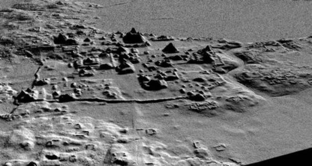
LIDAR scan reveals a network of roads, canals, corrals, pyramids, and terraces at El Mirador. [Credit: Archaeological Project Cuenca Mirador]

LIDAR technology used in the Mirador Basin made high-resolution 2D and 3D maps, allowing the researchers to get a three-dimensional view of the historic Basin without the canopy of jungle foliage getting in the way. The high-precision radar LIDAR scans the area, using a laser that can “penetrate the vegetation at a rate of 560,000 points per second.” Experts scanned and analyzed over 700 square kilometers of the Basin, in what Dr. Hansen said was a “one-of-a-kind study ever to be conducted in Mesoamerica.” Using both 2D and 3D images, they discovered walls, canals, pyramids, dikes, corrals, and terraces, but most important was the network of 17 roads, some of which were over 240 kilometers long and 40 meters wide. Researchers say the roads would have been used for freight transport.

Main: A pyramid covered in vegetation at El Mirador (Dennis Jarvis / flickr). Inset: A Maya stela found at El Mirador (CC by SA 2.0)

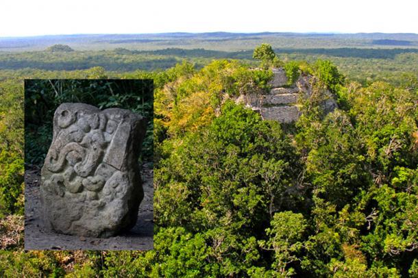
Main: A pyramid covered in vegetation at El Mirador [Dennis Jarvis / flickr]. Inset: A Maya stela found at El Mirador [CC by SA 2.0]

In addition to the unique network of roads, they have learned a great deal, including that Guatemala has the highest pyramids, and was the “cradle of the Maya civilization.” Researchers believe that the corrals, or animal pens, they discovered through the LIDAR scans were first established by El Mirador inhabitants. Dr. Hansen reports that he believes the “sophisticated system of corrals is evidence that meat production in the Mirador Basin may have existed on an industrial level,” but that more research is necessary in order to confirm this.

This discovery of an ancient network of roads, and previously unknown pyramids, means that the Mirador Basin Project researchers have even more sites to investigate, and they hope that any future findings can help us understand why the civilization declined. In order to discover more information on this long-ago civilization, Dr. Hansen “urges the governments of Guatemala and Mexico – as far as ‘El Mirador’ extends – to support protecting the area and boosting sustainable tourism.” According to the Mirador Basin Project website, the basin is being considered for protection by the Congress of the Republic of Guatemala, as a wilderness area. Discuss in the LIDAR forum at 3DPB.com.

[Sources/Images: Yucatan Times / Ancient Origins]


Share this Article


Recent News

Liquid Metal 3D Printing Sector Emerges with Fluent Metal’s $5.5M Investment

3DPOD Episode 191: Amy Alexander, 3D Printing at the Mayo Clinic


Categories

3D Design

3D Printed Art

3D Printed Food

3D Printed Guns


You May Also Like

3DPOD Episode 190: Generative Design for 3D Printing with Novineer CEO Ali Tamijani

Ali Tamijani, a professor in the Department of Aerospace Engineering at Embry-Riddle Aeronautical University, has an extensive background in composites, tool pathing, and the development of functional 3D printed parts,...

Featured

3DPOD Episode 189: AMUG President Shannon VanDeren

Shannon VanDeren is a consultant in the 3D printing industry, focusing on implementation and integration for her company, Layered Manufacturing and Consulting. For nearly ten years, she has been involved...

3DPOD Episode 188: Clare Difazio of E3D – Growing the Industry, and Growing With the Industry

Clare DiFazio’s journey into the 3D printing industry was serendipitous, yet her involvement at critical moments has significantly influenced the sector. Her position as Head of Marketing & Product Strategy...

Featured

Printing Money Episode 15: 3D Printing Markets & Deals, with AM Research and AMPOWER

Printing Money returns with Episode 15! This month, NewCap Partners‘ Danny Piper is joined by Scott Dunham, Executive Vice President of Research at Additive Manufacturing (AM) Research, and Matthias Schmidt-Lehr,...