
How 3D Aerial Laser Scanning Helped Discover a Massive Medieval City Hidden Under Cambodian Jungles


Massive trees and vegetation has overgrown most of the ruins at Angkor Wat, hiding a massive city underneath.
The Cambodian temple city complex of Angkor Wat is one of the largest religious monuments in the world, but until 2015 we had no idea how huge it was. A group of archaeologists led by Dr. Damian Evans have discovered a vast network of cities, roads, elaborate water systems and gardens surrounding Angkor Wat that were hidden beneath the thick tropical forest floor. The cities are believed to be between 900 and 1,400 years old and several of them rival Phnom Penh, the Cambodian capital, in size. At the time, this would have been the largest empire in the world, and no one even knew that they were there. These groundbreaking discoveries have completely upended everything that we believe that we knew about the history of medieval southeast Asia.
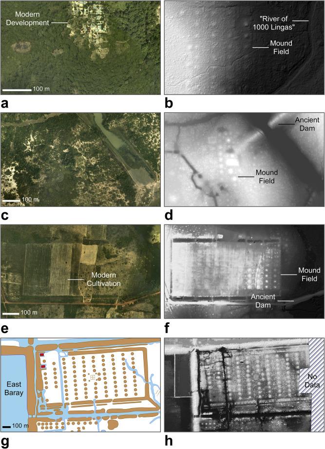
Aerial photos compared to the models captured by LIDAR technology.
Some of the incredible discoveries include an extensive water management system that apparently existed hundreds of years before we had believed it was created. Along with a complex network of roads, the water systems connected the cities to each other, as well as connected them to a large number of mysterious geometric patterns that were formed from earthen embankments. Evans suggests that these could have been elaborate gardens, however they will need to excavate and examine some of them in order to find out for sure. All of these findings have completely changed existing theories on the Khmer empire, how influential it was at the time and how and why it declined in the 15th century.
“Our coverage of the post-Angkorian capitals also provides some fascinating new insights on the ‘collapse’ of Angkor. There’s an idea that somehow the Thais invaded and everyone fled down south – that didn’t happen, there are no cities [revealed by the aerial survey] that they fled to. It calls into question the whole notion of an Angkorian collapse,” Evans told the Guardian.
The discovery of the massive cities were made thanks to the use of advanced airborne laser scanning technology called LIDAR (Light Detection And Ranging), a surveying technology that rapidly fires lasers at the ground from an aircraft. LIDAR is capable of penetrating thick vegetation and foliage in order to map the topography of the ground beneath the forest floor. The powerful lasers are fired down to the ground from a helicopter that passes over the ground being surveyed in a specific pattern in order to capture the entire area completely. The 2015 airborne survey is the largest archaeological project to ever use LIDAR technology and it covered more than 734 square miles of Cambodian jungle.
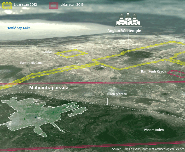
A comparison of the 2015 LIDAR survey compared to a smaller survey in 2012.
“The results for Preah Khan of Kompong Svay are truly remarkable and are arguably the jewel in the crown of this mission. The lidar shows us that there was much, much more. It’s both humbling and exciting. There are so many fantastic new discoveries. We knew that Preah Khan of Kompong Svay was significant before the lidar – it’s the largest complex ever built during the Angkorian period at 22 sq km, it is connected to Angkor directly by a major road fitted with infrastructure, and likely played a role in facilitating iron supply to the capital. The new results suggest that it may have been more important than many temples built in Angkor and that it had a decent-sized population supporting it,” explained Dr. Mitch Hendrickson, assistant professor in the department of anthropology at the University of Illinois and director of the industries of Angkor project.
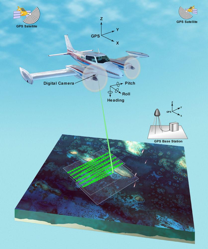
LIDAR technology
Previous to LIDAR technology, the creation of digital elevation models was primarily accomplished with photogrammetry, a process of using photographs to determine measurements and topography. LIDAR is significantly more accurate however, and has replaced photogrammetry as the most accurate method of collecting topographical data. The primary advantage is the ability of the lasers to penetrate dense vegetation and produce a more accurate representation of the ground beneath it. This allows highly accurate representations of roads, paths, ruins, geological features and cultural heritage sites to be converted into a 3D point cloud model.
A LIDAR survey begins with a predetermined flight plan using GPS that includes the altitude, the flight path and the airspeed. A 3D airborne laser scanner (ALS) is mounted on a helicopter or on an unmanned drone and the lasers pulse the terrain with about 16 laser beams in each square meter. The ALS includes a highly sensitive sensor that measures the amount of time it takes the laser to hit the ground and bounce back to it. It uses this data to detail the elevation of each individual data point and slowly generate the cloud model.
In order to compensate for the various foliage and soft features that would be captured by the lasers, the sudden changes in ground height are compared to existing models of the terrain. Data points that are determined to be foliage based on these existing models are essentially ignored and removed from the model. The remaining data is them processed into a 3D model of the terrain, illuminating the actual landscape and geologic features. The resolution that is capable of being captured by the narrow, high speed lasers can be as fine as 30 centimeters.
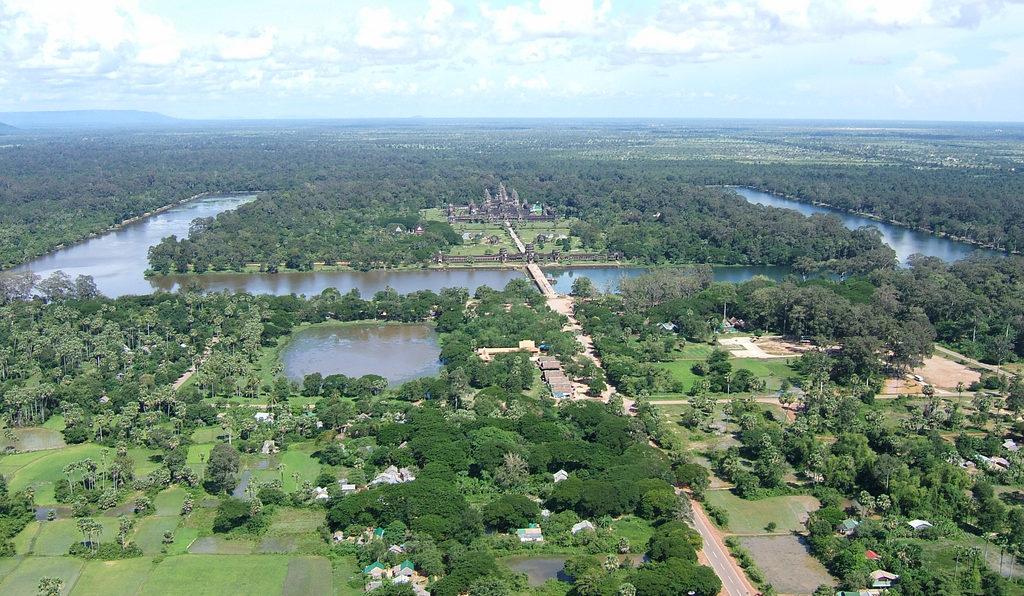
The temple city at Angkor Wat and the surrounding jungle hides a massive city that would have been the largest empire in the world during the 14th century.
Evans recently published his discovery of the cities at Angkor in the Journal of Archaeological Science, and he also spoke about them at the Royal Geographic Society in London. He believes that the discovery of these cities will challenge a lot of assumptions about the Khmer empire. His findings are already expected to be used for future excavations, including a research project on Longvek and Oudong, two of the post-Angkorian capital cities. Dr. Martin Polkinghorne from the department of archaeology at Adelaide’s Flinders University will using the data extensively on several scheduled excavations well into 2019.
A ruined statue hidden in the jungles of Cambodia near Angkor Wat. [Photograph: Terence Carter]
“The decline of Angkor is among the most significant events in the history of south-east Asia, but we do not have a precise date for the event. By using lidar to guide excavations on the capitals of Cambodia that followed we can determine when the kings of Angkor moved south and clarify the end of Angkor. Cambodia after Angkor is customarily understood in terms of loss, retreat and absence; a dark age. Yet, Cambodia was alive with activity after Angkor. South-east Asia was the hub of international trade between east and west. Using the lidar at Longvek and Oudong in combination with conventional archaeology we will reveal the dark age as equally rich, complex and diverse,” Polkinghorne explained.
The massive survey at Angkor was only one of the first of many archaeology projects that will be benefiting from advanced LIDAR technology. As LIDAR improves in quality and accuracy, and software algorithms that remove vegetation and ground debris improves, it can help us understand the ancient and long forgotten worlds of the past more completely than ever. You can read the entire article about the amazing discovery at Angkor over on the Guardian.
And here is a video of Dr’ Evans discussing his project and the LIDAR technology. Discuss further in the 3D Printed Ancient Cities forum over at 3DPB.com.
Subscribe to Our Email Newsletter
Stay up-to-date on all the latest news from the 3D printing industry and receive information and offers from third party vendors.
Print Services
Upload your 3D Models and get them printed quickly and efficiently.


You May Also Like
Caltech Uses 3D Printing to Rethink the Lithium-Ion Battery
For more than two decades, lithium-ion batteries have powered almost everything around us. They are inside smartphones, laptops, electric vehicles, drones, and even many medical devices. Batteries have improved a...
3D Printing News Briefs, July 1, 2026: Prosthetics, Drug Delivery, & More
We’re focused on healthcare and research in today’s 3D Printing News Briefs, including 3D printed prosthetics, patient-specific implants, drug delivery, and more. Read on for all the details! Students from...
New Study Shows Electronics Could Be Manufactured Directly in Space
A team of researchers from Auburn University and NASA Marshall Space Flight Center has successfully demonstrated a new additive manufacturing (AM) process that could allow astronauts to manufacture electronic components...
3D Printing News Briefs, June 24, 2026: Name Change, Digital Foundry, & Yeast
In today’s 3D Printing News Briefs, we’re starting with a formal name change for an African industrial technology company that’s a major user of additive manufacturing (AM) in the oil...