Oslo, Norway Makes 3D Printing an Integral Part of Future Urban Planning with 3D Printed Model of City

 If you visit the Agency for Planning and Building Services in Oslo, you’ll see the results of the agency’s monumental effort to create a complex, small-scale model of the Norwegian city. The 3D printed model replaces a previous, decade-old, conventionally produced 3D model that needed to be updated. However, updating the earlier model would have been an expensive undertaking. A 3D printed solution was proposed in 2012 but the progress was slow. The agency had purchased an A3 3D printer but lacked the expertise to use it and there simply weren’t that many examples of successful projects similar to what agency team members aspired to.
Finally, in early 2014, the eight-member team picked up the pace. Development of the 2D basemap, which became a direct reference for the eventual 3D printed model, began in earnest. The basemap was used to isolate the city of Oslo into sectors. Existing structures, areas where projects were underway, and future development projects were included in the 3D model.
The 3D printed model of Oslo, which covers an area of 34.8 km2 within the city’s central area, is divided into 360 blocks of around A3 DIN size (standard sizing for drawings, diagrams, and large tables). Overall, the 3D printed model measures 7.6m x 4.5m. The scale is 1:1,000.
The 3D model was printed using two 3D Systems ZPrinter 650 3D printers. It was assembled on a wooden platform. Every block is detachable; that is, you can pull it out of the larger model for closer examination. This segmented approach makes it much easier and clearly less expensive to update the model when necessary. Each of the blocks or segments is comprised of different layers of data compiled in ZEdit Pro by Portland, Oregon-based Peak Solutions.
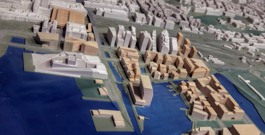
The main portions of each block consist of a terrain model, 2D cartographic information, and 3D buildings. The terrain models are based on LIDAR (Light Detection and Ranging) data, remote sensing used to examine the surface of the Earth, which is adjusted to smooth out terrain and eliminate height or gap issues that might otherwise occur in the 3D printed model.
One of the major benefits of using the ZPrinter 650 is the ability to print in full color. Designers used XFactor (First Interactive AS) and GISLINE (Norkart AS) to convert the 3D polylines. Autodesk’s 3D Studio Max was used to create the buildings within the future development areas; to do this, designers consulted urban plans made available by Oslo’s Department of Urban Planning.
Putting it all together once the necessary data was aggregated was no small feat. The team used ZEdit Pro, which enables users of 3D mechanical CAD software to verify and ensure that geometric 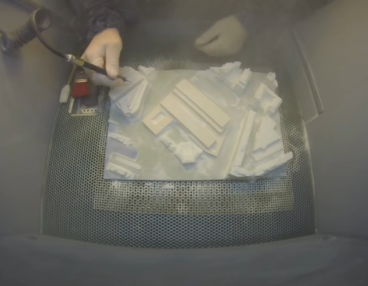 data is printable, even with files that were not intended to be 3D printed. With ZEdit Pro the model designers could apply colors, labels, and texture maps. The software doesn’t automatically interpret the SOSI (geospatial vector data format) and the data was so extensive that the project team had to invent some fixes in lieu of appropriate software. They improvised rather ingeniously, developing and producing a custom-made, laser-cut wooden frame upon which each block or segment from the overall 3D printed model was placed. Once the blocks were put in place, elevation variances in the terrain were eliminated. This also meant they could use less printer material and the individually printed blocks were lighter. Another cost-saving method was employed: Holes in the bottom surface of each block meant that all excess material could be extruded and reused.
When the 3D printing got underway, six members of the team rotated between building and printing blocks, which gave them all task and experience variety. Two of the other project members worked in support capacity and performed tasks like laser cutting and data conversion.
The largest exclusively 3D printed model in the country, it is displayed in the lobby of the agency where it serves as an interactive information platform. Moreover, it is an invaluable aid to urban planning.
“One of the team’s future goals,” said Oslo’s Agency for Planning and Building Services, “is to make smaller 3D models that will not be permanent, but mobile and can be used in different public space such as libraries, or in events such as architectural exhibitions.”
Let us know what you think in the 3D Printed Oslo forum thread over at 3DPB.com. Check out the video below of the process.
[Source: 3ddeconference.com]Subscribe to Our Email Newsletter
Stay up-to-date on all the latest news from the 3D printing industry and receive information and offers from third party vendors.
Print Services
Upload your 3D Models and get them printed quickly and efficiently.


You May Also Like
trinckle’s Tool Design Software Lands in Stratasys GrabCAD Print
I’m a fan of trinckle, the German startup that offers super easy-to-use tools for creating customized jigs, fixtures, and other 3D printed products. With trinckle, it’s not just designers who...
Caracol Taps CNC Robotics to Build and Support Its UK Systems
No matter how quickly the economy seems to be changing on the surface, there is no escaping the fact that geography is the foundation of economics, and, in case anyone...
EOS Buys Metalpine, but What’s Behind the Move?
EOS has bought Austrian powder manufacturer Metalpine. EOS doesn’t buy companies often. And with increased competition from China & SLM, profligate spending doesn’t seem like it would be a good...
ExOne Cuts Costs for U.S. Customers as Printhead Production Moves to Detroit
ExOne Global Holdings, created through the 2025 integration of ExOne and voxeljet, is making changes across its U.S. operations. These include starting printhead manufacturing in the Detroit area and lowering...