San Francisco Bay Depicted in 3D Printed Topographical Map by Area Resident

 Being able to visualize our terrain is a very important detail in life, whether you do it on a GPS, paper map, drawing, or often — as in our hometowns — simply from an almost aerial view in your mind due to repetition in driving, walking, and giving verbal directions.
Understanding the geography of our surroundings is a basic need and a survival mechanism. The art of topography has also lent deep expression and richness to human history through the ages, despite the technology or crafting employed to make a detailed description of any landscape.
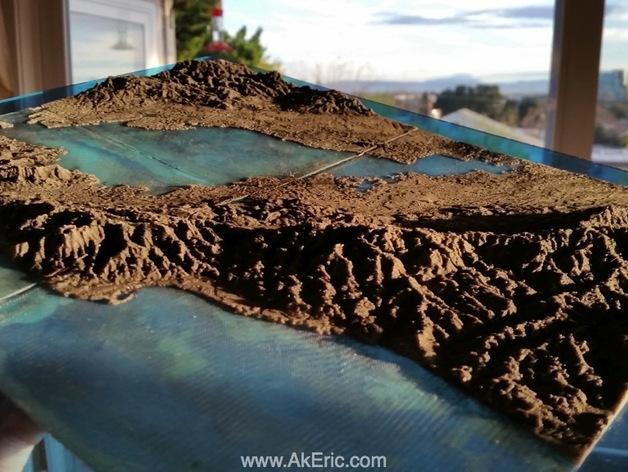
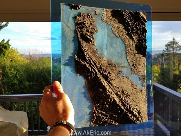
While we have previously reported on 3D printing and the city landscape of San Francisco depicted in a grand and impressive urban display, recent work by Eric Pavey gives us a more technical 3D printed topo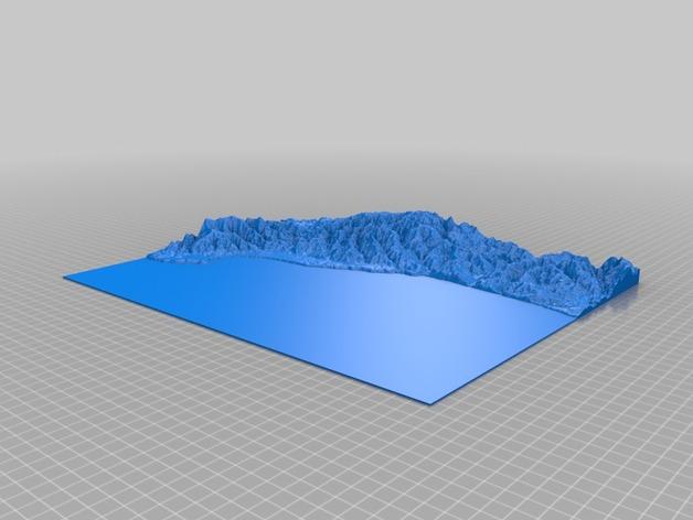 graphy, of the San Francisco Bay. Officially discovered in 1769 by Spanish explorer Gaspar de Portolà, the San Francisco Bay has never ceased in garnering its share of attention as the home of the Golden Gate Bridge, and a popular recreational area for boaters and water sports enthusiasts. The Bay also functions as the largest Pacific estuary, and a very important ecological habitat.
3D printing enthusiast Pavey, who makes his career as a technical artist in the video games industry, wanted to translate his love for the area into a tangible visual description.
“After making virtual things for so long, it’s been nice to turn my talents into making ‘real’ objects,” Pavey told 3DPrint.com.
He was inspired by Thatcher Chamberlin’s software program, Terrain2STL, which allowed him to create the topographical map of San Francisco Bay. As Pavey pointed out, Terrain2STL performed “the heavy lifting of the map geometry creation,” which he shared on Thingiverse so anyone who might be interested can download the files and 3D print their own San Francisco Bay, or be inspired to customize a topographical map of their design.
Terrain2STL allowed Pavey to identify the San Franscisco Bay in Google Maps. With one simple download, he received the 3D printable .stl file of the terrain to take the next step with slicing and 3D printing. Pavey was also able to collaborate with Thatcher, who advised him on how to make the shoreline visible in the map since it is directly at sea level. By adding thickness to the ground and manipulating the water area, Pavey was able to get the topographical design closer to sense of accuracy he was striving for.
“I live in the San Francisco Bay area and find it to be an amazingly beautiful place, and I wanted another way to wrap my head around its scope and scale,” said Pavey.
 Pavey used MakerBot Desktop as a slicer, setting the prints to maximum size and working to use a “translucent effect” on the ocean, with a pre-slice preview assessing that there were two levels for the ocean. Pavey was able to set the firmware to pause so he could make a filament change, starting with neon blue PLA and then switching to light gray PLA. Using his MakerBot Replicator 1 for 3D printing, Pavey estimated that each region took 2.5 to 3.5 hours to complete, using Sailfish firmware.
Pavey added some finishing touches to the map at the end to accentuate the ocean’s transluscency. Using a piece of light blue acrylic as a backdrop, he also used epoxy on the back of each region, and to add relief to the mountains, added black spray paint as an accent.
“I’m always looking for new things to try to print, and topo maps seemed like a great thing to try. I found the Terrain2STL tool just at the right time, all the pieces fell into place, and this great map was the result,” said Pavey.
San Francisco is rich in history, with a long connection to maritime trade. Pavey’s homage to San Francisco Bay gives us all a detailed technical view of one of the most famous worldwide natural harbors.
Are you interested in 3D printing a topographical map? Tell us about it in the 3D Printed Topographical Map forum over at 3DPB.com.

Subscribe to Our Email Newsletter
Stay up-to-date on all the latest news from the 3D printing industry and receive information and offers from third party vendors.
You May Also Like
Profiling a Construction 3D Printing Pioneer: US Army Corps of Engineers’ Megan Kreiger
The world of construction 3D printing is still so new that the true experts can probably be counted on two hands. Among them is Megan Kreiger, Portfolio Manager of Additive...
US Army Corps of Engineers Taps Lincoln Electric & Eaton for Largest 3D Printed US Civil Works Part
The Soo Locks sit on the US-Canadian border, enabling maritime travel between Lake Superior and Lake Huron, from which ships can reach the rest of the Great Lakes. Crafts carrying...
Construction 3D Printing CEO Reflects on Being Female in Construction
Natalie Wadley, CEO of ChangeMaker3D, could hear the words of her daughter sitting next to her resounding in her head. “Mum, MUM, you’ve won!” Wadley had just won the prestigious...
1Print to Commercialize 3D Printed Coastal Resilience Solutions
1Print, a company that specializes in deploying additive construction (AC) for infrastructure projects, has entered an agreement with the University of Miami (UM) to accelerate commercialization of the SEAHIVE shoreline...