LiDar and its Applications Part 2 – Digital Elevation Modeling

Naturally, when I saw a list of various applications of LiDar and 3D Scanning in various industries, I wanted to learn more. This article will have a focus on dimensional elevation modeling and how it utilizes LiDar and 3D scanning for industrial needs.
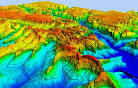
A digital elevation model refers to 3D computer graphical representation of a terrain that is found readily within Earth. We can also extend this to different environments such as space. So we can represent mountainous lands, the moon, and even asteroids with the proper digital elevation model (DEM). One can further specific models as a discrete global grid.
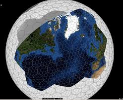
A discrete global grid is a mosaic that spans the entire Earth’s surface. This is done through the mathematical method of space partitioning. This refers to a set of filled regions that form a part of the Earth’s surface.
DEMs are typically used within geographic information systems. The most common way to do so is through the usage of digitally produced relief maps. We can further classify DEMs through the following categories:
- Digital Surface Models
- Digital Terrain Models
DSMs are useful for landscape modeling, city modeling, as well as visualization applications. A digital terrain model is often used for flood or drainage modeling, land-use studies, geological applications, and many more.
How does LiDar assist with this? Digital elevation data is captured in raster files. These files are taken with the photographic abilities of the LiDar device. The data files are typically found in the following formats:
- .tif
- .adf
- .flt
- .img
- TIN
The techniques used to create digital elevation models range from simple to complex. LiDar technology sits more in the middle of this. With photogrammetry, LiDar is able to take multiple photos with a rotation mechanism. Lasers then are able to scan a large environment. To do this, we probably need to have airborne mechanisms. This is where one can deploy LiDar along with drones to collect our data.
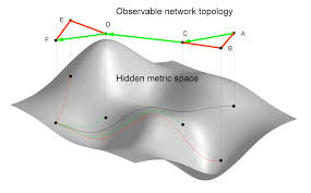
Topology becomes of utmost importance to digital elevation modeling. We are able to learn a lot about a large terrain through the topological overview. LiDar gives us access to this in ways that are not attainable from our grounded states. When looking at a topological view of terrain, we are in a 2D format. This is how data is stored quickly, because 3D data requires a lot of space. The terrain can be typically remodeled later through adding a component of height with our topology data.
This is the first step of understanding for LiDar, and this will allow us to see quickly how to apply these thoughts into various industries.
Subscribe to Our Email Newsletter
Stay up-to-date on all the latest news from the 3D printing industry and receive information and offers from third party vendors.
You May Also Like
Slice Engineering and Egyptian NGO Give Amputees Free 3D Printed Prosthetics
Florida-based Slice Engineering believes that additive manufacturing can reshape industries and make a lasting impact on humanity, and so works hard to empower innovators and professionals. The company does this...
3DPOD Episode 197: Ceramics 3D Printing with Johannes Homa, Lithoz CEO
Lithoz is a pioneer in the 3D printing of technical ceramics, initially using a ceramic-loaded stereolithography process and later adopting multiple technologies. Johannes Homa, a researcher turned entrepreneur, discusses his...
AddUp Announces Deputy CEO & Innovations in Medical & Injection Molding AM
Global metal 3D printer OEM AddUp, a joint venture between French tire giant Michelin and Paris-based industrial engineering corporation Fives, appointed Julien Marcilly as its new CEO at the end...
Lithoz Expands Ceramic 3D Printing to Japan via New Network
Lithoz is securing the future of its ceramic 3D printing technology in Japan with the formation of a new coalition with leaders from the country’s ceramics and manufacturing industries. Together...