LiDar and its Applications Part 10 – Flood Prevention


Floods have various impacts on environmental ecosystems. Some of these can be positive, while others are very detrimental. Flooding is a natural ecological process that plays an integral role in ensuring biological productivity and diversity within a flood plain. There are a myriad of impacts in the detrimental sense. This typically includes environmental degradation. Flood damage is usually the most extensive and difficult to repair within the environment. Flooding directly impacts the health and well-being of wildlife and lifestock. A list of problems associated with flooding includes riverbank erosion and sedimentation, the dispersal of nutrients and pollutants, restructuring of surface and groundwater resources, as well as landscape editing of habitats. So how can we use LiDar to mitigate some of the problems with floods, and maybe use floods to our benefit?
We have outlined the importance of risk analysis within our series a number of times so far. In flood modeling, small changes in elevation are the difference between a high risk flood zone and low risk. LiDar is used to model floodplain morphology. A floodplain is an area of low lying flat land that is seasonally submerged by overspill from neighboring rivers, lakes, or swamps. Based on elevation levels, we can predict a good amount of flood risk before a flood occurs.

New Orleans Hurricane Katrina Flood Map
Flood risk evaluation has a lot of nuances to the overall problem. There lies a lot of uncertainties and typical oversight from observed data. This is most difficult to solve when we are analyzing the LiDar data from 3D terrains of flat lands. Flat lands have extremely small changes within their land surface elevation models. The presence of man made structures also significantly changes the flood distribution and variable flow of a flood. In order to analyze flood risks in flat lands, we focus our attention to LiDar and its capabilities in micro-topography.
We have briefly explained micro-topography before. Micro-topography and LiDar analysis allows us to measure micro changes within topological maps. We can use this data from our Digital Terrain Models as well as Digital Elevation Models to now make better predictions of ebbs and flows within a flood, or the likelihood of a flood to even occur. A good river and floodplain description is possible using high resolution input data. Advancements in modeling and remote sensing technologies such as LiDar make it possible to generate high resolution DEMs at a reasonable cost. We can produce DEMs with accuracy less than ±25 cm, depending on the land cover, slope, flight parameters and environmental conditions.
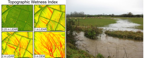
DEMs for microtographic analysis in wetlands
The ability to analyze land in a microscale fashion is so useful for this field of study. Within the larger context of 3D data, being able to go from the macroscale to microscale is of utmost importance. The ability to use this for our prevention of major destruction is important. We cannot take care of unexpected large scale random events, but most of the predictable events can be taken care of.
Join the discussion of this and other 3D printing topics at 3DPrintBoard.com.
Subscribe to Our Email Newsletter
Stay up-to-date on all the latest news from the 3D printing industry and receive information and offers from third party vendors.
Print Services
Upload your 3D Models and get them printed quickly and efficiently.


You May Also Like
Mimaki & Cleeks Golf Club Collaborate for Miniature 3D Printed Golf Bag Collectibles
Japan-headquartered Mimaki Engineering launched its first full-color inkjet printer in 1996. Not long after, the company established its US-based Mimaki Inc. operating entity, which manufactures digital printing and cutting products, including...
HeyGears Unveils G1X, the World’s First Desktop Full-Color 3D & UV Printer
For creators, makers, studios, and small businesses, color has remained one of the biggest barriers in digital fabrication. Multi-color FDM is limited in detail and often creates waste towers, while...
Goal! 3D Printing for the 2026 FIFA World Cup
The 2026 FIFA World Cup officially kicked off in Mexico City on June 11th. It’s the largest FIFA tournament in history, with 48 teams competing over 104 matches. Instead of...
AMPulse Asia: Creality IPO Headlines APAC 3D Printing Market Roundup
Asia’s additive manufacturing sector spent the back half of May moving capital and capacity, not just demos. Chinese desktop and consumer printer makers pushed onto public markets, metal powder producers...