Datasthesia: 3D Printed Relief Maps Give Us Information About Our World

 It’s now evident that when the disciplines of industrial design and data science converge, the results take you beyond just stunning visuals: they fascinate, and teach.
Thanks to the efforts of two dynamic artists, Karen and Marcelo, collaborating with the use and experimentation of 3D printing, the public is able to take away even more from an experience like visualizing the Earth and corresponding topography.
We’ve followed 3D printed topography before such as that of San Francisco or even Oahu depicting basic geographical locations, but generally in the context of residents who enjoy living in those places and also have an interest in map making. In this project, we are looking at several levels of interest–and information.
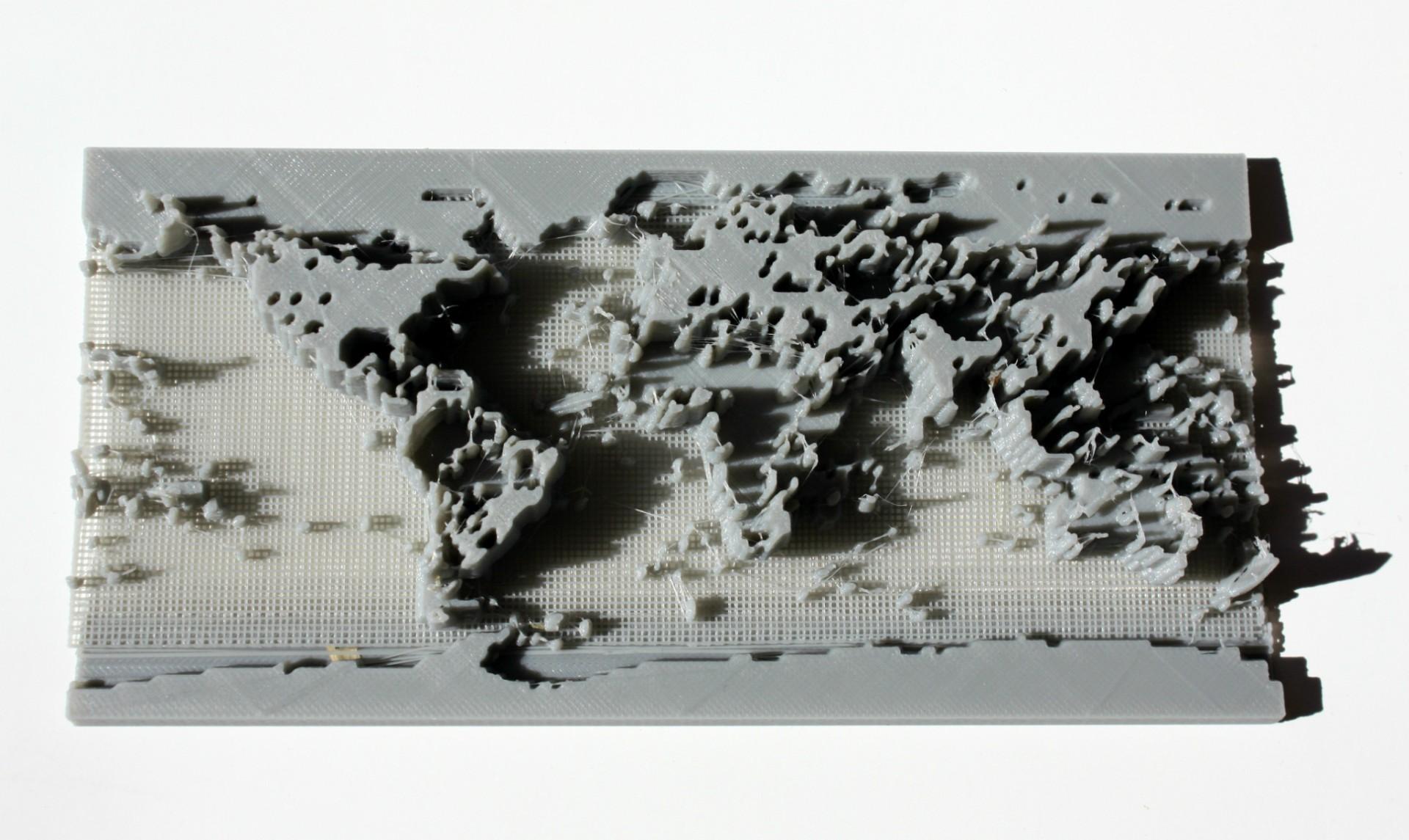
‘Population Density’
Karen Antorveza, an illustrator and industrial designer, and Marcelo Rinesi, a data analyst, have formed the Datasthesia team along with several ‘domain experts,’ who help with each specific project. The team believes that the visual aspects we all enjoy and rely on so much can also be greatly enhanced by ‘data embodiment,’ which allows us to perceive physical objects uniquely.
“We are both curious about each other’s field of work (Karen’s is Industrial Design, while Marcelo’s is Data Science), and we both dabble in different arts (music and writing), so we came up with Datasthesia as a way of putting everything together adn play with a form of art that has bits of all of that, but it’s also something entirely different,” Karen told 3DPrint.com. “We choose each new project after a lot of emails, and sometimes cups of tea, bouncing ideas about what sort of topics and techniques we happen to be curious about. We don’t have any outside mandate or limitations other than what we think we might be able to get away with, and trying something new and having it crash and burn isn’t a problem, which is one of the fun aspects of Datasthesia.”
The ‘Population Density’ project, which shows what happens when art and data merge, culminated in showing us what is perhaps not only the future of geographical photography, but map making as well. When starting on the project, they needed a good source of data, however–and what better source than that from NASA.
“Luckily, there’s a well-known first order approximation used by economists, which is the amount of night illumination visible from space,” states the team on their blog. “This tends to have a good correlation with economic activity, as it reflects levels of wealth as well as population sizes. And NASA has precisely what we needed: eerily beautiful worldwide images of nighttime Earth from space, put together as if it was night on the whole planet.”
Using Python for digital design, the Datasthesia team originally–and quite ambitiously–sought to create a 3D printed globe. After trial, error, disaster, and frustration, they shifted their efforts to a more concise relief map. Still challenging and not without technical glitches along the way, they were able to reach their goal in 3D print, but are refining it further still.
In their next project, ‘Wikidata,’ the team followed the same process but their goal was a bit different, more complex, and with a very unique aim.
“This time, though, our goal was to show the geographical distribution of geotagged articles in the English version of Wikipedia, extracting the data from a map built by Mark Graham at the Oxford Internet Institute,” states the team on their website. “There are obvious spatial correlations between the maps, but there are also fascinating differences — places’more interesting’ (at least to Wikipedia contributors) than what they population densities would imply.”
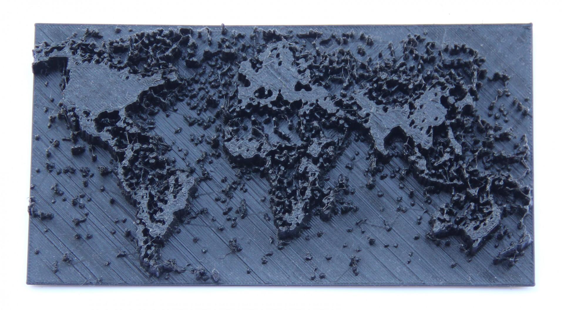
‘Wikidata’
With the goal of finding new ways of ‘saying things’ with objects, the Datasthesia really has created a new type of art that conveys fascinating information. Not just the type of display that you want to glance over quickly and run, both ‘Population Density’ and ‘Wikidata’ invite you to study them at length and reflect on the actual data they show, offering us an overview of us planet and basically, what everybody is up to–and where.
Aware that this is a new art, both Karen and Marcelo are more than willing to brave putting their new ideas and 3D printed representations out there, errors and all.
“We have at least one more 3D printed map in the pipeline — something we’ve done before, but we are experimenting with new ideas for the software we wrote to generate them — as well as a couple of other projects that have nothing to do with anything else we’ve done before (and that’s an understatement! We are very excited to see whether or not they come out in some workable form),” Karen told 3DPrint.com. “We’ve also [begun] to work in earnest with other groups; one of the projects mentioned above involves a third person with a wholly different background and motivation for the project, which is a fantastic way to keep Datasthesia from ever falling into a rut. We love getting in touch and working with other people in the 3D printing and data analysis communities, but most of the fun comes from working with people doing completely unrelated things.”
Subscribe to Our Email Newsletter
Stay up-to-date on all the latest news from the 3D printing industry and receive information and offers from third party vendors.
You May Also Like
3D Printing News Briefs, April 13, 2024: Robotics, Orthotics, & Hypersonics
In 3D Printing News Briefs today, we’re focusing first on robotics, as Carnegie Mellon University’s new Robotics Innovation Center will house several community outreach programs, and Ugogo3D is now working...
Rail Giant Alstom Saves $15M with 3D Printing Automation Software 3D Spark
3D Spark has entered into a three-year deal with the rail giant Alstom. Alstom, a transport behemoth with annual revenues of $16 billion, specializes in the manufacture of trains, trams,...
Meltio Expands Global Reach with New Partnerships in the Americas and Europe
Spanish 3D printing manufacturer Meltio has expanded its sales network across the globe. With the addition of three new partners in the United States, Brazil, Argentina, and Italy, Meltio aims...
3D Printing Webinar and Event Roundup: April 7, 2024
Webinars and events in the 3D printing industry are picking back up this week! Sea-Air-Space is coming to Maryland, and SAE International is sponsoring a 3D Systems webinar about 3D...