LiDar and its Applications Part 6 – Forest Fires


Welcome back people! I really cannot thank you all enough for your continuous readership. It makes my nerdy habits of research and technology obsession more acceptable Without the continuous reading and reviewing of my articles, I would be writing all of this in a void that lacked any enjoyment. For anyone who reads my articles and would love to give me comments or even hatred please email me at esehud@gmail.com. I love learning new perspectives, especially from people within these fields. I would love to hear from others who are deeply in their fields that I talk about (anyone an expert in drones and LiDar truly contact me as I’d like to test out some drones for a product review). To get back on topic, let’s talk about saving the trees a bit more.
In a previous article, we talked about the importance of planning and forest management. Management is all about risk tolerance. Optimizing risk is the goal. So let’s talk about the risky stuff. FIRE. I like fire personally. I like welding when bored or being around a metal shop because sparks are everywhere. Trees, however, don’t. Forest fires are one of the most critical risks that can cause the destruction of a large scale forestry environment.
From January to October 2019, there were 41,064 wildfires in total around the US. This is compared to in 2018 numbers of the same time frame being 47,853 wildfires. These statistics are from the Interagency Fire Center. Over the last ten years, there seems to be an oscillating trend of forest fires around 67,000 wildfires annually as well as 7.0 million acres of land burnt annually. This shows that there does not look to be a trend of progress or regress in terms of mitigation of fires over a decade. This can be interpreted in many ways, and frankly I do not have a lot of information or research to say why the data is so. I can make an assumption that technology has been a part of this equation though in terms of managing forest fires.
![]()
LiDar allows for preventative maintenance of land through risk analysis for areas that are prone to wildfires, and it also has the ability to sense things such as wind currents in live time. This allows for knowledge of how a fire may spread due to natural forces. It makes life a fire somewhat more predictable, but again life is not. It gives us ideal insight though for areas that are of severe risk, and people can plan for this accordingly.
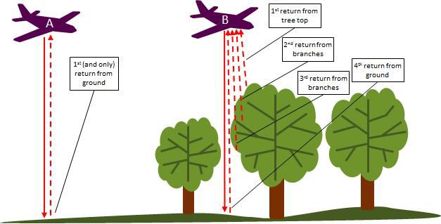
We have discussed at length topography, digital terrain models, and digital elevation models in this series. Surveying and photogrammetry are of importance to these methods. This is the typical method for creating DTMs, DEMs, and topographical based maps, but LiDar is a more modern form of operations. The previous methods were used because of their efficiency and ability to record elevation info well below a typical vegetation cover within a forest. These methods were not great for how time consuming they are. Airborne LiDar is used because it has low sensitivity to vegetation cover compared to photogrammetry and other surveying methods.
Lidar DTMs are created using a last response return to a sensor within the device. This comes from interaction with a laser pulse. These can be refined using filtering algorithms which we have talked about before in articles on laser scanning. This can remove responses created by trees or other vegetation, rendering us able to see if a source point for a fire.
I talk at length about the environmental applications of LiDar and 3D environment data, but it makes a lot of sense. Without these developments in technology a lot of guesswork would be done to plan and prevent issues when it comes to our environment.
Join the discussion of this and other 3D printing topics at 3DPrintBoard.com.
Subscribe to Our Email Newsletter
Stay up-to-date on all the latest news from the 3D printing industry and receive information and offers from third party vendors.
Print Services
Upload your 3D Models and get them printed quickly and efficiently.


You May Also Like
How One Artist Is Using 3D Printing to Tell Stories About the Ocean
Artist Kimberly Callas sees something different when she looks at a 3D printer. Where others see a machine for making parts, she sees a way to tell stories about the...
Bambu Lab Wants Home 3D Printing to Feel Less Like a Workshop with PLA Pure
As desktop 3D printers become increasingly common in homes, Bambu Lab is focusing attention on something beyond print speed and hardware features. This week, the company launched a new filament,...
AM Asia Watch: China Exported 2.46 Million 3D Printers in Four Months
China’s consumer 3D printer industry seems to be reaching a new level of global dominance. According to Chinese state media outlet China Global Television Network (CGTN), China exported 2.46 million...
Bambu Launches A2L: What the New Printer Reveals About Its Strategy
Bambu Lab continues its relentless march for 3D printing domination with the launch of the A2L. The 330 × 320 × 325 mm printer will have a nozzle temperature of...