3D Printed Topographic Map Visualizes Australian Farmland and Water Sources

The Department of Agriculture and Food, Western Australia (DAFWA) advocates for and advances the economic  development of the food and agriculture sector in Western Australia. It’s main focus is on food export-led growth and, in order to encourage industry productivity and sustainability, the DAFWA is increasingly turning to cutting-edge technology. One recent effort to expand knowledge of the proximity of arable land to water sources in Western Australia utilized 3D printing to create a three-dimensional map representing hydro-geological interactions.
A major agricultural effort, the La Grange project south of Broome in the Kimberley region of Australia, has a 3.5 million hectare groundwater area, including a major aquifer called the Broome aquifer. Researcher, Nick Wright, wanted to be able to create a direct visual representation of the physical relationship between the land and the aquifer. The goal was not to create a model of detailed precision but something to aid in presentations. “It’s not meant to be a super-precise representation of what’s going on,” explained Wright. “It’s about creating a conceptual model, so people understand how the different units interact with each other.”
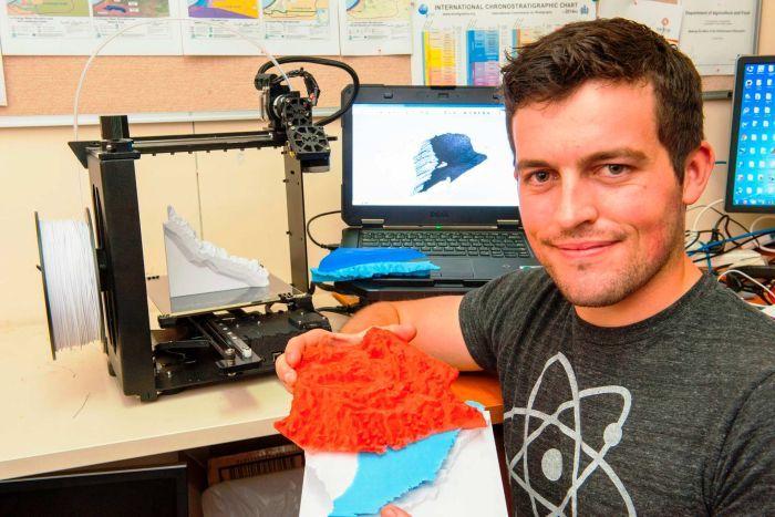
Wright combined data collected on surveys of the La Grange area with data collected by NASA. He spent a month working with the data to develop a system of computer modeling that would yield a fully three-dimensional, 3D-printed map. Although he had originally hoped to draw from similar models, Wright learned after an extensive search that nobody else was really doing what he had in mind. He realized that he was pioneering a new process that he hoped would be used more widely.
One of the major goals of Wright’s 3D mapping project was to find a way to demonstrate visually how the Broome aquifer flows from inland towards the ocean. The model he eventually produced had multiple, interlocking layers. Rather than looking at a flat map and imagining the variations in elevation, the contours, as with a traditional
Autumn Vineyard on a stormy day
topographic map, Wright’s 3D-printed map can be picked up, rotated, and studied from all sides. “We were using it at a seminar a couple of weeks ago,” Wright related, “to explain the data we’ve collected over the past couple of years about the irrigation opportunities and constraints.”
As far as the viability of the project for other organizations that would benefit from Wright’s process, the largest expense would, of course, be the purchase of a 3D printer. As the models are relatively small, very little filament is required to produce one, although the multi-colored effects would require a 3D printer that could print in multiple colors.
Since completing the La Grange project, Wright has used the technology to create a model of the water run-off at the Muchea saleyards, also in Western Australia. The Muchea Livestock Centre is the largest undercover livestock selling center in Australia.
As for the usefulness of the modeling technology he designed, combined with 3D printing capabilities, Wright said, “It’s so applicable. To turn a farm into a 3D model of the topography would probably take a couple of hours of software manipulation. You could print it out in an afternoon and see the features of what you’ve been driving over for the past 50 years printed out in the palm of your hand.”
What are your thoughts on yet another very interesting use for this technology? Can you think of any other similar applications for 3D Printing? Discuss in the 3D Printed Topographic Map forum thread on 3DPB.com.
Subscribe to Our Email Newsletter
Stay up-to-date on all the latest news from the 3D printing industry and receive information and offers from third party vendors.
Print Services
Upload your 3D Models and get them printed quickly and efficiently.


You May Also Like
Reuniting ExOne and voxeljet: An Investor’s View on Building a Global Industrial Sand Printing Leader
Authored by Whitney Haring-Smith, Chair of the Board, ExOne Global Holdings & Managing Partner, Anzu Partners At Anzu Partners, we invest with conviction in industrial technologies that create categories—and then...
Adoption of Advanced Powder Metal Manufacturing in the Global Small Arms Space – SHOT Show 2026 Additive Manufacturing Analysis
Back in 2013, I remember being completely blown away when a company called Solid Concepts reportedly additively manufactured nearly a complete firearm as a proof of concept. Although desktop polymer...
AM-Europe, operated by CECIMO: Positioning Additive Manufacturing at the Core of Europe’s Industrial Competitiveness
As European industries face growing pressure to strengthen resilience, reduce supply chain risks, and meet sustainability objectives, additive manufacturing (AM) is emerging as a practical and strategic solution. Closely align...
Five Imperatives for CAD and PDM In The Additive Era
Additive manufacturing has reached an inflection point. Hardware capabilities continue to advance, materials portfolios are expanding rapidly, and automation is reshaping post‑processing and production workflows. Yet many additive programs still...